User:Crewgles
No edit summary |
No edit summary |
||
| Line 1: | Line 1: | ||
{{ | {{MapsList|Sunset Isle| | ||
*'''Battle Tiers: 6-★''' | *'''Battle Tiers: 6-★''' | ||
*'''Size: 42x42 km''' | *'''Size: 42x42 km''' | ||
*'''Replay File Name: xxx_56_AngleWings.wowreplay | *'''Replay File Name: xxx_56_AngleWings.wowreplay | ||
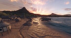
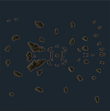
This map captures the atmosphere of the Torres Strait. It's located in a remote area between Australia and New Guinea, which was a key route for the Australian Navy as it sailed to Port Moresby. Japanese aircraft and submarines were frequently present in the Torres Strait, attacking land installations and hunting for Allied ships—especially early in the war. It's also home to the historic Green Hill Fort, which was originally built in the 19th century and was repurposed during World War II. This map is with Tier VI ships up to superships in Random and Co-op Battles using the [[Ship:Game Modes#Arms Race|Arms Race]] and [[Ship:Game Modes#Domination|Domination]].}} | This map captures the atmosphere of the Torres Strait. It's located in a remote area between Australia and New Guinea, which was a key route for the Australian Navy as it sailed to Port Moresby. Japanese aircraft and submarines were frequently present in the Torres Strait, attacking land installations and hunting for Allied ships—especially early in the war. It's also home to the historic Green Hill Fort, which was originally built in the 19th century and was repurposed during World War II. This map is with Tier VI ships up to superships in Random and Co-op Battles using the [[Ship:Game Modes#Arms Race|Arms Race]] and [[Ship:Game Modes#Domination|Domination]].}} | ||
Revision as of 21:21, 6 July 2026
- Battle Tiers: 6-★
- Size: 42x42 km
- Replay File Name: xxx_56_AngleWings.wowreplay
